Geography of the United States
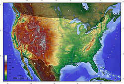
Relief map of the 48 states of the U.S. mainland
Area
Total 9,629,090 km2
Land 9,158,960 km2
Water 470,131 km²
Latitude 38°0' N
Longitude 97°0'W
Borders
Canada 8,893 km
Mexico 3,327 km
Coastlines 19,920 km
The United States is a country in the Western Hemisphere. It consists of forty-eight contiguous states in North America, Alaska, a peninsula which forms the northwestern most part of North America, and Hawaii, an archipelago in the Pacific Ocean. There are several United States territories in the Pacific and Caribbean. The term "United States", when used in the geographical sense, means the continental United States, Alaska, Hawaii, Puerto Rico, Guam, and the Virgin Islands of the United States. The country shares land borders with Canada and Mexico and maritime (water) borders with Russia, Cuba, and The Bahamas.
Area
By total area (water as well as land), the United States is either slightly larger or smaller than the People's Republic of China, making it the world's third or fourth largest country.China and the United States are smaller than Russia and Canada in total area, but are larger than Brazil. By land area only (exclusive of waters), the United States is the world's third largest country, after Russia and China, with Canada fourth. Whether the US or China is the third largest country depends on two factors:
(1) The validity of China's claim on Aksai Chin and Trans-Karakoram Tract. Both these territories are also claimed by India, so are not counted;
and (2) How US calculates its own surface area. Since the initial publishing of the World Factbook, the CIA has updated the total area of United States a number of times. From 1989 through 1996, the total area of the US was listed as 9,372,610 km2 (3,618,780 sq mi) (land + inland water only).
The listed total area changed to 9,629,091 km2 (3,717,813 sq mi) in 1997 (Great Lakes area and coastal waters added), to 9,631,418 km2 (3,718,711 sq mi) in 2004, to 9,631,420 km2 (3,718,710 sq mi) in 2006, and to 9,826,630 km2 (3,794,080 sq mi) in 2007 (territorial waters added). Currently, the CIA World Factbook gives 9,826,675 km2 (3,794,100 sq mi),[5] the United Nations Statistics Division gives 9,629,091 km2 (3,717,813 sq mi),[6] and the Encyclopædia Britannica gives 9,522,055 km2 (3,676,486 sq mi).
General characteristics
The United States shares land borders with Canada (to the north) and Mexico (to the south), and a territorial water border with Russia in the northwest. The contiguous forty-eight states are otherwise bounded by the Pacific Ocean on the west, the Atlantic Ocean on the east, and the Gulf of Mexico to the southeast. Alaska borders the Pacific Ocean to the south, the Bering Strait to the west, and the Arctic Ocean to the north, while Hawaii lies far to the southwest of the mainland in the Pacific Ocean.
Forty-eight of the states are in the single region between Canada and Mexico; this group is referred to, with varying precision and formality, as the continental or contiguous United States, and as the Lower 48. Alaska, which is not included in the term contiguous United States, is at the northwestern end of North America, separated from the Lower 48 by Canada. The State of Hawaii is an archipelago in the Pacific Ocean. The capital city, Washington, District of Columbia, is a federal district located on land donated by the state of Maryland. (Virginia had also donated land, but it was returned in 1847.) The United States also has overseas territories with varying levels of independence and organization.